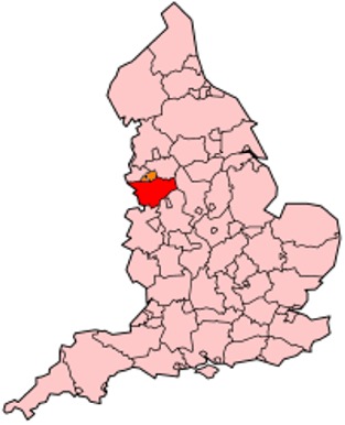
Maps of Cheshire County England
Home > Maps of England > Cheshire County Maps
Welcome to our Cheshire County map page. The map of Cheshire England that is located below is provided by Google Maps. You can "grab" the electronic map and move it around to re-center the map. You can change between standard map view and satellite map view by clicking the small square on the bottom left-hand corner of the map. Satellite map view utilises orbiting satellite and / or aerial high-resolution photography to display images of the map location to street level detail (really quite amazing). Standard map view shows a traditional street map (also known as a road map). You can use the zoom buttons on the bottom right-hand side of the map to zoom in or out to street level detail. We have digital online maps for most towns and cities on the Maps of England page. We also have a good collection of old school printable maps on the Maps of England page.
A map of Cheshire County, England
I hope you like the Cheshire County, England+ 2 End United Kingdom Maps
Cheshire County Maps
Alsager |
Altrincham |
Antrobus |
Arley |
Birkenhead |
Bollington |
Bramhall |
Cheadle |
Cheadle Hulme |
Chester
Cholmondeley |
Congleton |
Crewe |
Croft |
Culcheth |
Disley |
Dukinfield |
Ellesmere Port |
Frodsham |
Golborne
Hale |
Haslington |
Holmes Chapel |
Hyde |
Kinsey Heath |
Knutsford |
Lymm |
Macclesfield |
Malpas |
Marple
Middlewich |
Nantwich |
Neston |
Northwich |
Over Peover |
Pott Shrigley |
Poynton |
Prestbury |
Reddish |
Romiley
Runcorn |
Sale |
Sandbach |
Stockport |
Stretton |
Tarporley |
Tattenhall |
Timperley |
Warrington |
Waverton
Weaverham |
Widnes |
Wilmslow |
Winsford
Cheshire County Map
Cheshire also known, archaically, as the County of Chester is a ceremonial county in North West England. The traditional county town, is the city of Chester, although Cheshire's largest town in terms of area and population is Warrington. Other major towns include Congleton, Crewe, Ellesmere Port, Widnes, Runcorn, Macclesfield, Nantwich, Northwich, and Wilmslow. The county is bordered by Merseyside and Greater Manchester to the north, Derbyshire to the east, Staffordshire and Shropshire to the south, Flintshire and Wrexham in Wales to the west.
The ceremonial county has an overall area of 2,344 square kilometres (905 sq mi) and has a population of about 993,200.
The county is mostly rural with a number of small towns and villages that support an agricultural industry. It is historically famous for the production of Cheshire cheese, salt, bulk chemicals and the weaving of silk.

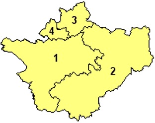
Districts of Cheshire County

1. Cheshire West and Chester
2. Cheshire East
3. Warrington
4. Halton
Permission is granted to copy, distribute and/or modify this document under the terms of the GNU Free Documentation License, Version 1.2 or any later version published by the Free Software Foundation; with no Invariant Sections, no Front-Cover Texts, and no Back-Cover Texts. A copy of the license is included in the section entitled "GNU Free Documentation License".
From Wikipedia, the free encyclopedia
Music


