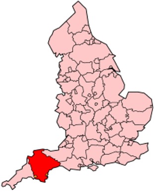
Maps of Devon County England
Home > Maps of England > Devon County Maps
Welcome to our Devon County map page. The map of Devon England that is located below is provided by Google Maps. You can "grab" the electronic map and move it around to re-center the map. You can change between standard map view and satellite map view by clicking the small square on the bottom left-hand corner of the map. Satellite map view utilises orbiting satellite and / or aerial high-resolution photography to display images of the map location to street level detail (really quite amazing). Standard map view shows a traditional street map (also known as a road map). You can use the zoom buttons on the bottom right-hand side of the map to zoom in or out to street level detail. We have digital online maps for most towns and cities on the Maps of England page. We also have a good collection of old school printable maps on the Maps of England page.
I hope you like the Devonshire, England+ 2 End United Kingdom Maps
Devon County Maps
A
Abbotskerswell | Appledore | Ashburton | Ashcombe | Ashwater | Axminster
B
Bampton |
Barnstaple |
Beaford |
Beer |
Belstone |
Bere Alston |
Bere Ferrers |
Berrynarbor |
Bickleigh |
Bideford
Bigbury |
Bishop's Nympton |
Bishopsteignton |
Blackawton |
Bovey Tracey |
Bradninch |
Bradworthy |
Branscombe
Bratton Clovelly |
Bratton Fleming |
Braunton |
Brayford |
Brendon |
Brentor |
Bridestowe |
Bridgerule |
Brixham
Broadclyst |
Buckfastleigh |
Buckland Brewer |
Buckland Monachorum |
Budleigh Salterton |
Burrington
C
Chagford |
Challacombe |
Chardstock |
Cheriton Bishop |
Cheriton Fitzpaine |
Chittlehampton |
Christow
Chudleigh |
Chulmleigh |
Clyst Honiton |
Clyst Hydon |
Clyst St George |
Clyst St Mary |
Cockington |
Coldridge
Collaton St Mary |
Colyton |
Combe Martin |
Cornwood |
Cornworthy |
Countisbury |
Crediton |
Croyde |
Cullompton
D
Dalwood | Dartington | Dartmouth | Dawlish | Dittisham | Doddiscombsleigh | Dolton | Dunkeswell | Dunsford
E
East Allington | East and West Buckland | East Anstey | East Prawle | Ermington | Exeter | Exminster | Exmouth
F
Feniton | Filleigh | Fremington
G
Galmpton | Georgeham | Great Torrington
H
Halberton |
Halwill |
Harberton |
Harbertonford |
Hartland |
Hatherleigh |
Hawkchurch |
Heanton Punchardon
Heathfield |
Hemyock |
High Bickington |
Holbeton |
Holsworthy |
Honiton |
Hope Cove |
Horrabridge
I
Ilfracombe | Ilsington | Instow | Ipplepen | Ivybridge
J
K
Kentisbury |
Kenton |
King's Nympton |
Kingsbridge |
Kingskerswell |
Kingsteignton |
Kingston |
Kingswear
Knowstone
L
Lapford | Lifton | Loddiswell | Lundy Island | Lustleigh | Lydford | Lympstone | Lynmouth | Lynton and Lynmouth
M
Marldon | Martinhoe | Mary Tavy | Meeth | Membury | Merton | Modbury | Molland | Moretonhampstead
N
Newton Abbot |
Newton Ferrers |
Newton Poppleford |
North Bovey |
North Molton |
North Tawton
Northam |
Northlew
O
Okehampton | Otterton | Ottery St Mary
P
Paignton | Parkham | Parracombe | Payhembury | Petrockstowe | Plymouth | Plympton | Plymstock | Princetown
Q
R
Rackenford | Rockbeare | Rousdon
S
Salcombe |
Sampford Peverell |
Seaton |
Shaldon |
Shaugh Prior |
Shebbear |
Shirwell |
Sidbury |
Sidmouth
Slapton |
Sourton |
South Brent |
South Molton |
South Tawton |
South Zeal |
Stockland |
Stoke Fleming
Stoke Gabriel |
Stokenham |
Strete |
Swimbridge
T
Tavistock |
Tedburn St Mary |
Teignmouth |
Thorverton |
Throwleigh |
Thurlestone |
Tiverton |
Topsham
Torcross |
Torquay |
Totnes |
Trentishoe
U
Uffculme | Ugborough | Umberleigh | Uplyme | Upottery
V
W
Walkhampton |
Wembury |
West Down | Westleigh |
Westward Ho | Whimple |
Widecombe-in-the-Moor | Willand
Winkleigh | Witheridge |
Woodbury | Woolacombe
X
Y
Yarcombe | Yealmpton | Yelverton
Z
Devon County Map
Devon is a large county in South West England. The county is also referred to as Devonshire, but that is an entirely unofficial name, rarely used inside of the county but often indicating a traditional or historical context. The county shares borders with Cornwall to the west and Dorset and Somerset to the east. Its coastline follows the English Channel to the south and the Bristol Channel to the north. It is the only county in England with two separate coastlines.
Devon is the third largest of the English counties and has a population of 1,109,900. The county town is the cathedral city of Exeter, and the county contains two independent unitary authorities: the port city of Plymouth and the Torbay conurbation of seaside resorts, in addition to Devon County Council itself. Plymouth is also the biggest city in Devon. Much of the county is rural (including National Park) land, with a low population density by British standards. 365 square miles (950 km2) are occupied by Dartmoor.
The county is home to part of England's only natural UNESCO World Heritage Site, the Dorset and East Devon Coast, known as the Jurassic Coast for its geology and geographical features. Along with its neighbour, Cornwall, Devon is known as the "Cornubian massif". This geology gives rise to the landscapes of Dartmoor and Exmoor, which are both National Parks. Devon has seaside resorts and historic towns and cities, and a mild climate, accounting for the large tourist sector of its economy.

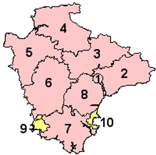
Districts of Devon County

1. Exeter
2. East Devon
3. Mid Devon
4. North Devon
5. Torridge
6. West Devon
7. South Hams
8. Teignbridge
9. Plymouth
10. Torbay
Permission is granted to copy, distribute and/or modify this document under the terms of the GNU Free Documentation License, Version 1.2 or any later version published by the Free Software Foundation; with no Invariant Sections, no Front-Cover Texts, and no Back-Cover Texts. A copy of the license is included in the section entitled "GNU Free Documentation License".
From Wikipedia, the free encyclopedia
Music


